Neolithic avant-garde village in Israel drowned by tsunami from Mount Etna
Around 8000 BC, sea levels rose to –33 meters in relationto the present, enough to re-establish communication between the Mediterranean and the Black Sea, with a possible effect on relations between Western Anatolia and Eastern Europe. By 7000 BC, the sea begins to invade the Persian Gulf; around 6000 BC, it reaches -12 meters to the present; around 5000 BC, it reaches its present level and will from that time on only undergo minor fluctuations. The great rivers (Euphrates, Tiger, Karun) had filled in their beds; the level of the groundwater table had risen in lower-Mesopotamia, transforming life-conditions in a region which heretofore had been a desert. The coastlines of the Eastern Mediterranean were less spectacularly affected; however, at the foot the Carmel mountains, 7th millennium villages end up underwater, at a depth of -8 to -10 meters, at a distance of some 100 meters from the present shoreline.
Whereas ritual, in the Pre-Pottery Neolithic B (PPNB) period, is shaped by the human community and expresses itself through a dominant « vitalist » human-animal symbolism, in the Pottery-Neolithic (PN), its is deeply marked by domestication. A clear social hierarchy cannot be shown to exist either in the PPNB nor in the PN, except for probable village reunions. The community ritual in the PPNB and the decoration of ceramics in the PN are considered to be symbolic, society-regulating systems. The emergence, out of the PPNB foundation, of the Neolithic Pottery society (probably constituted of paesants, but also of nomadic pastors and hunter-gatherers) seems to have resulted from the interaction of complex socio-economic factors.
The final PPNB shows the progressive deterioration of the PPNB world.
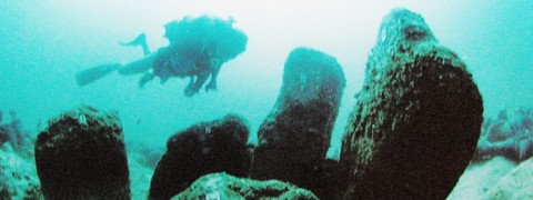
Atlit Yam is a sub-marine archaeological site situated off the coast of Israel, near the city of Atlit, south of Haifa, at the foot of Mount Carmel. This submerged village is the most ancient submarine archaeological site known to this day, dated to 6900 to 6300 BC (Pre-Pottery Neolithic B final / C). This 40,000 square meter site, lying 12 meters underwater, produced a circle of erected stones, the most ancient stone-lined well ever found, the most ancient cases of tuberculosis and malaria, the longest life-expectancy of the period and the first example of a Mediterranean fishing village the economy of which was simultaneously based on the resources of the sea and of the land, the basis of what is known to us today as the Mediterranean diet.
We can postulate the existence of five types of different marine habitat in this region in the time of the Pre-Pottery Neolithic C:
- a rocky coast ca 3-5 km long on the Western slope of the peninsula (the crest of Tira presently submerged to the North of the village);
- several square kilometers at very low depth (0-5 m) of rocky sea bottom to the West of the peninsula;
- a shallow sandy lagoon covering ca 1-2 square kilometers to the East of the peninsula;
- relatively deep (16-25m) rocky marine bottoms over ca 4-5 square kilometers (at present, a submerged sandstone crest at a depth of 32-42 m);
- a sandy beach ca 8 km de long, with a sandy marine bottom which could have harbored mollusks, crabs and fish.
A launchpad for the Mediterranean Diet
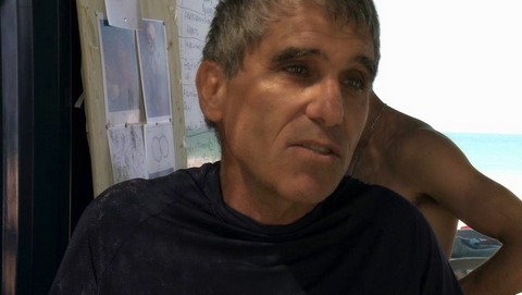
Atlit-Yam was discovered in 1984 during a dive by archaeologist Ehud Galili (picture), who spotted a rough stone tumulus, which turned out to be a well; it was dated by carbon14 to the 7th millennium BC. It is built of dry stones, with a diameter of 1.5 meters and a depth of 5.5 meters. The fill contains silex, stone artifacts and animal bones in two separate layers. The superior level contains partly articulated animal bones which were probably thrown into the well after it stopped being used. Other round structures on the site may also have been wells. Galili estimates that the water in the wells was little by little contaminated by sea water, which forced the inhabitants to abandon their dwellings after seven centuries, over which the community seems to have stayed remarkably stable.
The inhabitants lived in spacious stone dwellings, with paved floors, yards, fireplaces, storage facilities and wells. Some 70 structures have been found, most of them rectangular in shape. There were no roads laid out. Some thirty families must have lived in the village.
Scientists have found the trace of more than 100 plant species which grew on the site or had been plucked in their natural environment, there are bone remains of wild as well as of domesticated animals such as sheep, goats, pigs, cattle, and dogs; which suggests that the inhabitants were also practicing hunting. In fact, the transition from wild to domesticated animals is well covered on this site: young aurochs are found, as well as primitive domesticated goats. The top layer of the fill of the well contains only domesticated animals.
Wild plants include wild grapes, poppies and caraway seeds. Granary weevils indicate that cereals were being stored. There were stores of wild grain. Pollen analysis shows the presence of swamp plants, therefore of swamps. There was also wheat, barley, and chick-peas, which were cultivated.
At the beginning of summer, grain harvesting would succeed to fishing; then there would come the slaughtering of animals born in Spring; then the harvesting of fruit; in autumn, back to fishing and sea-food; picking of wild vegetables in winter; then came the season for sowing, to be followed again by fishing in the spring. Almost everything we know as the Mediterranean Diet is already in place. Temperatures were 3°C lower than today on average, with more severe winters, heavy winter storms, and colder sea water. The North-American ice-sheet was still in the process of melting, and the sea level was rising by half a meter per century.
The average size of fish caught corresponds to catches made with nets of vegetal fibre, indicating the probable use of linen, for nets as well as for ropes and the making of clothes. Well-preserved tombs of 65 individuals have been recovered. Many skeletons display dental diseases and dental damage associated with the fabrication of fishing nets, as well as, in four individuals, damage to the inner-ear which must have been caused by diving for sea-food in cold waters.
There are also problems with vertebrae, abrasions at the elbows, and evidence on the bones of strong muscle development signalling intensive rowing activity.
The population residing at Atlit-Yam around 6900 BC to 6300BC had to face up to illnesses such as malaria which is widespread in coastal swamps, as well as tuberculosis and other infections. A woman and child buried together and discovered in 2008 show the earliest case known of tuberculosis. This was discovery rewrote medical history, as it revealed that, contrary to what had been believed up to now, TB was not transmitted to humans by cows, in the process of domestication, but the other way round, cows had inherited the disease from humans.
Atlit Yam may also have brought to the fore the first case of thalassemia ever found. One individual in the PPNB stratum shows a pattern of characteristic deformation of porous hypersotosis on a diseased humerus, indicative of clinical thalassemia.
Yet, despite illnesses and difficulties, half the population lived to the age of fifty and beyond, which is an advanced age in relation to the societies living in the Levant in the Neolithic. It seems that their balanced “Mediterranean diet” contributed to their health and longevity. The level of aggression seems to have been low. Based on the skeletons, the average height was 1.44m for the women, 1.64m for the men. There are morphological resemblances with the individuals found at Khirokitia (Cyprus), which might point to a biological relation between these two groups. Whereas little fishing activity is evident in Cyprus until a much more recent period, the digging of wells is a typically Cypriot cultural trait.
The persons buried at Arlit Yam have been found with many stone axes, more than in other archaeological sites of this period, which seems to indicate the presence of a community of carpenters specialized in ship-building, also serving neighboring communities. These boats may not have been bigger than canoes, but they could navigate the sea arms and passages of a coastal Mediterranean which was shallower than today. If men were buried with axes, women were buried with grinders…
Pollen of olive trees has been found, but the lack of olive stones at Atlit Yam indicates that the pressing of olives for oil was still a millennium away. (The following megalithic period at Neveh Yam, on the bay of Atlit Yam, as well as in Kfar Samir, Kfar Galim and Megadim on the coast south of Haifa brought to the fore thousands of olive pits and remnants of the production of olive oil.)
A pocket Stonehenge
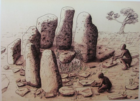
In the center of the village there is a ritual installation of megaliths: a miniature version Stonehenge, older than Stonehenge by 4,000 years - a cromlech, in fact. It’s a half-circle made of stones, 2.5 m in diameter, constituted of seven menhirs of 600K each. The monoliths, some more than 2m high, are disposed like sentinels around a central stone, symbolically surrounded by a basin to contain water. It seems to have been built around a fresh water spring. The stones have hollowed-out cupules suggesting they may have been used in a water ritual.
Close to the menhirs, to the West, some flat stone slabs (0.7-1.2 m long) have been found in a horizontal position. On some of them, shallow cupules have also been hollowed out.
Another installation is made of three oval stones (1,6 to 1,8 m), two of which are engraved with grooves forming schematic anthropomorphic figures.
The megalithic altar is surrounded with tombs and is reached by a curious, narrow corridor, 20 meters long. According to the archeo-astronomer Clive Ruggles, these parallel walls leading to the altar are oriented in the direction of the Summer solstice sunrise.
Ten tombs with bent corpses have been found, some under the floor of the houses and some in their vicinity. A few years after burial, the skull of the deceased was unearthed: Three skulls, without their lower jaw-bone, have been found, separated from their skeletons. The skulls were plastered with clay to fashion a mask, modelling the face, shells were used to figure the eyes and irises; a wig could have been added and the skull emplaced at the center of the village, maybe on a platform to be used for an ancestor cult?
Mathieu Amigalithe
(Translated, revised and expanded by Anne-Marie de Grazia)
This article is based on part of an article in French by Mathieu Amigalithe on megaliths published on the site Hominidés and completed with notes of the author published on his blog, as well as sources in the press.
Cromlech solsticial d'Atlit Yam
https://agupubs.onlinelibrary.wiley.com/doi/full/10.1029/2006GL027790
The tsunami

For Israeli archaeologists, it’s climate warming which caused the rise in the sea level, the wells having been infiltrated by salt water, the sea level having risen at least 16 meters since.
But according to Italian geophysicists, the village may have been submerged by a tsunami provoked by a collapse of a flank of Mount Etna.
Under a layer of clay, a store of several thousand fish, orderly laid out according to size and cut open to dry or to be salted, destined to local consumption or for trade, as well as a large amount of stored cereals seems to indicate that the village had been abandoned suddenly. An Italian study conducted by Maria Teresa Pareschi (picture) of the National Institute of Geophysics and Vulcanology in Pisa indicates that the collapse of the eastern flank of Mount Aetna in Sicily 8,500 years ago – the resulting mudslide created the depression known today as the Valle del Bove - would have triggered a tsunami 10 floors (40m) high, with a speed of 700m/h, (more powerful than the Indonesian tsunami of 2004 which killed 180,000 people) which would have submerged some Mediterranean coastal cities within hours. Southern Italy would have been submerged within 15 minutes, within an hour the tsunami would have reached the Western coast of Greece, after an hour and a half, the site of Benghazi in Lybia would have been affected. In 3 hours and 30 minutes, the tsunami would have crossed the whole of the Mediterranean Sea reaching the coasts of Lebanon, Israel and Syria in the East.
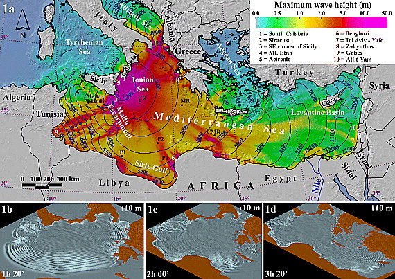
A mountain of debris would have crashed into the sea at a speed of 320km/h, blasting the sea bed, turning thick layers of marine sediments into a jelly, and triggered a submarine mudslide which would have flowed over hundreds of kilometres (the sediments of this ancient Etna mudslide cover 250 square kilometres of sea bottom). A computer modelizing was created of what would have happened when these 25 cubic kilometres of Etna rock crashed into the sea, and it was found that the resulting tsunami would indeed have reached the coast of Israel. Israeli scientists do not agree with this theory, pointing to the fact that the circle of megaliths is still standing where it was built.
The height of the tsunami wave reaching the Levantine coast would have been between 1 and 2m, which at first does not sound like much, but consider that, whereas a normal wave measures about 2 meters from crest to crest, the tsunami wave approaching the coast would have measured 80,000 meters (200,000 meters on the open sea) and collected itself like a spring, towering up on the shallow sea bottom in the seconds before hitting the land...
Go to the original article