

Piteraqs, Greenland's storms from hell
Marilena Oltmanns
The locals had an ill foreboding when, on November 22nd 2015, the sky over Eastern Greenland suddenly brightened. It shone in a blue, metallic cast.
A few hours later, it all started. An invisible avalanche crashed over the coast, like a brutal flashflood of icy air. At 250 km/hour, it flung around boats which were docked at the yards in Tasiilaq, which is, with its 2100 inhabitants, the largest town in the East of Greenland.
The inhabitants had barricaded themselves in their homes, but the storm, a so-called Piteraq, blew holes into many wood constructions. Piteraq means: "That, which throws one down."
Those who are unable to flee into heated dwellings usually don’t stand a chance before the minus 20° C storms. Drunks, for instance, happening to be taking a nap out-of-doors. Or those who are hiking in the wide mountains of Greenland and are taken by surprise by a Piteraq.
This happened to 31-year old Philip Goodeve-Docker, who froze to death three years ago, after a Piteraq tore his tent to shreds. He had planted it in the glacier wilderness. „We hugged him as fast as possible, in ordert to keep him warm,“ two of his companions reported. They were rescued from the cold by a helicopter crew, a few hours after after Philipp’s death.
On February 5, 1970, the wind was even stronger. In the afternoon, gusts of over 300 km/h tore so many homes to pieces that the inhabitants of Tasiilaq pondered, whether they should not simply give up on their city. "South Greenland has been battered by an eery hurricane,“ read the helpless title in the "Hamburger Abendblatt". Nobody knew what had really happened.
Even to this day, the uncanny Greenland storms have been barely studied. Traditionally, the locals fall back on a simple rule: if the sky brightens up suddenly and shines a metallic blue, things can turn bad.
Only in an old Greenland schoolbook could she find more precise explanations about Piteraqs, says Marilena Oltmanns from the Helmholtz-Center for Ocean Research at Kiel (Germany). After analyzing over 200 such weird storms she is now offering an explanation of the destructive phenomenon.
On satellite pictures of Greenland, something strange had caught her attention: from one day to the next, still icebound fjords of Greenland were suddenly free of ice after a Piteraq. „It was as if they had been swept clean,“ Oltmann noticed in amazement. What was going on?
The young scientist researched why the storms in Greenland could wind themselves up to such strength, and she is now offering her conclusions: she discovered multiplying effects, turning winds into storms – and storms into icy hurricanes, blowing with greater power than most hurricanes anywhere else in the world.
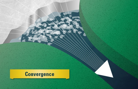
Harm on the way signals itself with an L on the weather chart, a low pressure zone. If, from the Southeast of Greenland, the low moves in a Northern direction, highest caution is on the order of the day – it means that a storm engine is getting into gear inside the low.
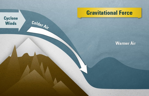
Atmospheric lows suck up air, because air is rising inside them; as a result, the pressure at ground level plummets. Before the coast of Greenland, the lows act almost explosively, because above the Greenland land mass itself dwells in permanence a polar opposite: an atmospheric high. Because the air cools abruptly above the ice sheet, which is at places three kilometers thick, the air sinks – and it weighs heavily on the land. The pressure rises.
The high air pressure seeks an outlet. A close-by low moving up the coast is just what’s needed: it sucks the icy Greenland air seawards. The wind starts blowing. But why, Marilena Oltmanns asked herself, can the breeze accelerate into becoming an icy air dump, a Piteraq?
A look at the data of Greenland weather stations stirred her suspicions: in the case of Piteraqs, the instruments register wind speeds of very varied intensities, some of them indicating even in the middle of the worst perturbations only moderate storm values, other instruments being quite simply torn apart by the wind. Oltmanns conclusions: the storms get reinforced locally.
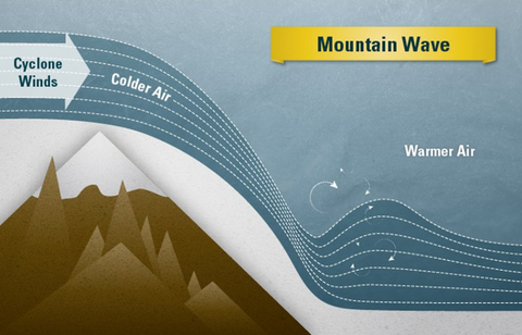
In the scientific literature, she stumbled on a remarkable phenomenon, which might well explain what is happening in Greenland: cold air masses, when they roll down mountain slopes, behave like breaker waves on the seashore. As soon as they start crashing like breakers on a beach, they accelerate with extreme force.
And it gets even worse: valleys and fjords border the coastline of Greenland. They channel the rushing storms. Air shoots through such narrowings like a bullet through the barrel of a gun. The city of Tasiilaq is situated just at the end of such a valley.
Accordingly, Piteraqs are at their fiercest on the coasts. Their force can break up the ice in front of the coastline and push it onto the open sea, opines Marilena Oltmanns. No wonder then, that the fjords get swept clean.
The greatest danger to humans occurs in coastal places which are situated both below bluffs and at the end of valleys. „There,“ according to Oltmanns, „a Piteraq can collide head-on with a settlement.“
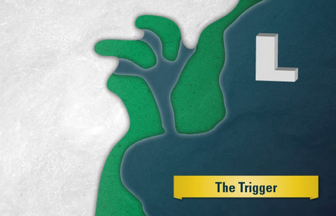
A LOW pressure system moving up the Coast
Axel Bojanowski, Der Spiegel, 30. March 2016
Translated from the German by Anne-Marie de Grazia
Original article here.
"This is called a "Dancer" in Esquimo tradition. It is sent by the Old Woman who lives at the bottom of the sea. It is one of her husbands, and it is higher than a mountain, and bigger than an ice floe and deeper than a ravine and it dances among the people by the light of the fire."
From Joel Carlinky